

Mehri Madarshahi | Crossing Climate Red Lines: When Mountains Begin to Move – Catastrophes in the Himalayas and the Changing Geography of Climate Risk
Sino-foreign Silk Road
Published: 2026/09/08
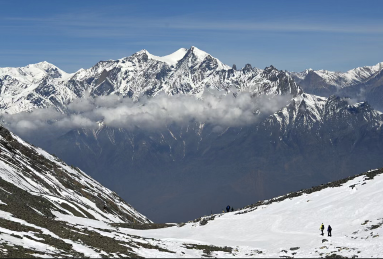
Introduction: On August 26, 2026, a large-scale glacier collapse occurred at Lirong Peak in Langtang, Nepal, causing ice and rocks to fall from a height, followed by ice and rock avalanches, mudslides and flash floods, which quickly transmitted downstream along the river valley and impacted the Xizang Jilong port in China, causing serious casualties and property losses. As of 18:00 on September 5, 43 people were killed and 519 lost contact at the Jilong port in China; 1,344 people were killed and 4,898 people lost contact in Nepal.The Himalayas are one of the most sensitive regions to global warming. The accelerated melting of glaciers and the continuous degradation of permafrost have reduced the stability of high-altitude mountains; while the terrain of alpine glaciers, with steep slopes and deep river valleys connecting end to end, makes it possible to destabilize the source in one place, and the risk can be transmitted downstream in a very short time. Similar chain risks are not unique – in August, Typhoon Nala hit northern Vietnam, causing floods and landslides due to heavy rainfall, which damaged roads, infrastructure and crops, and also showed a chain of risk transmission from meteorological events to geological disasters to infrastructure damage.
Mehri Madarshahi, an emeritus professor at the IPP, calls this change “the changing geography of climate risk.” Climate change is not only increasing the likelihood of a single hazard occurring, but also changing the physical connections between different hazards, with changes in where they occur, how they travel, and the people and infrastructure they expose. Prof. Madarshahi argues that building resilience cannot stop at post-disaster response, recovery, and reconstruction, but must move further to pre-disaster observation, anticipation, adaptation, protection, and transformation. If the geography of risk is changing, she emphasizes, the geography of resilience must change with it.
Crossing Climate Red Lines: When Mountains Begin to Move
The tragedy in the Himalayas and the changing geography of climate risk behind it

Author: Mehri MadarshahiMember of the Advisory Board of the International Centre for Creativity and Sustainable Development (ICCSD) under UNESCO
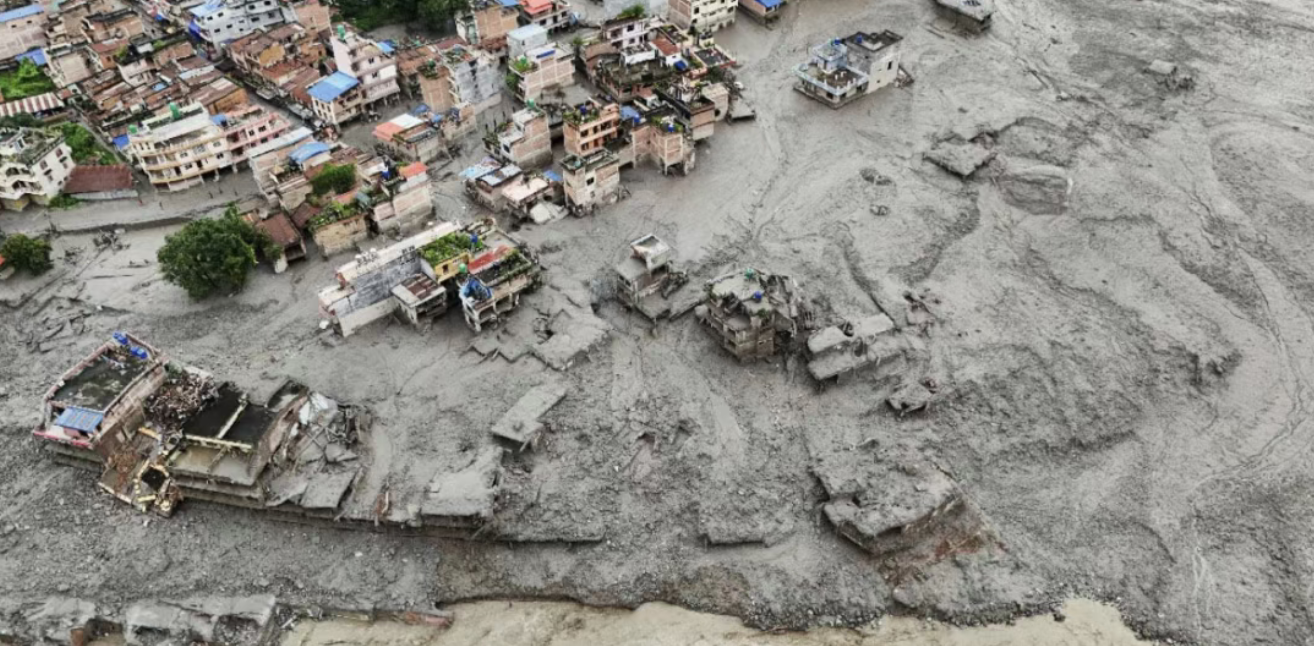
Introduction: On August 26, 2026, a large-scale glacier collapse occurred at Lirong Peak in Langtang, Nepal, causing ice and rocks to fall from a height, followed by ice and rock avalanches, mudslides and flash floods, which quickly transmitted downstream along the river valley and impacted the Xizang Jilong port in China, causing serious casualties and property losses. As of 18:00 on September 5, 43 people were killed and 519 lost contact at the Jilong port in China; 1,344 people were killed and 4,898 people lost contact in Nepal.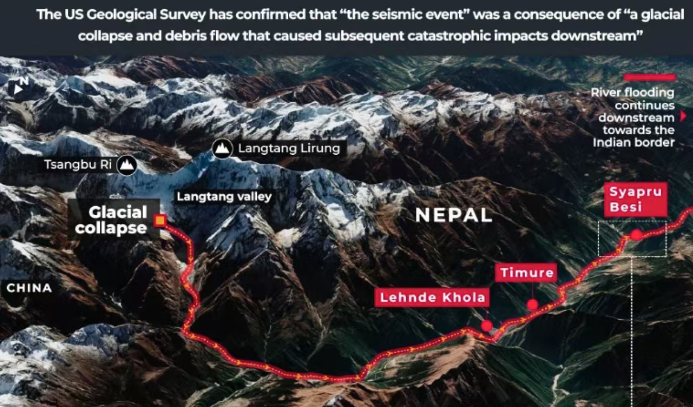
Introduction: On August 26, 2026, a large-scale glacier collapse occurred at Lirong Peak in Langtang, Nepal, causing ice and rocks to fall from a height, followed by ice and rock avalanches, mudslides and flash floods, which quickly transmitted downstream along the river valley and impacted the Xizang Jilong port in China, causing serious casualties and property losses. As of 18:00 on September 5, 43 people were killed and 519 lost contact at the Jilong port in China; 1,344 people were killed and 4,898 people lost contact in Nepal.
Crossing Climate Red Lines: When Mountains Begin to Move
Introduction: On August 26, 2026, a large-scale glacier collapse occurred at Lirong Peak in Langtang, Nepal, causing ice and rocks to fall from a height, followed by ice and rock avalanches, mudslides and flash floods, which quickly transmitted downstream along the river valley and impacted the Xizang Jilong port in China, causing serious casualties and property losses. As of 18:00 on September 5, 43 people were killed and 519 lost contact at the Jilong port in China; 1,344 people were killed and 4,898 people lost contact in Nepal.
Mehri Madarshahi, an emeritus professor at the IPP, calls this change “the changing geography of climate risk.” Climate change is not only increasing the likelihood of a single hazard occurring, but also changing the physical connections between different hazards, with changes in where they occur, how they travel, and the people and infrastructure they expose. Prof. Madarshahi argues that building resilience cannot stop at post-disaster response, recovery, and reconstruction, but must move further to pre-disaster observation, anticipation, adaptation, protection, and transformation. If the geography of risk is changing, she emphasizes, the geography of resilience must change with it.
The tragedy in the Himalayas and the changing geography of climate risk behind it
The ice itself also maintained the stability of the mountain.
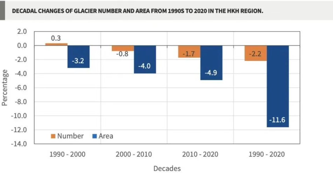
At high altitudes, permafrost penetrates deep into cracks in bedrock, acting as a “glue” to help stabilize steep mountains. As temperatures rise, this frozen “glue” begins to melt, water gradually seeps into the fissures, suspended glaciers continue to retreat and lose support, and rock walls that originally formed in one climate are increasingly exposed to changing climates.
Scientists are still studying the exact cause of the Aug. 26 instability, with recent investigations suggesting that prolonged glacial movement, unusually warm spring and summer temperatures, increased meltwater and degradation of high-altitude permafrost may have weakened the ice-rock contact zone.
Climate change need not be enough to simply “push down the first rock,” or to alter the environmental conditions that make mountains vulnerable.
It is at this point that Nepal’s disaster has revealed much more than just a mountain collapse itself.
The changing geography of risk
For most of human history, geography has had a degree of stability. Mountains are still mountains, rivers flow largely along recognizable channels, permafrost remains frozen for long periods of time, and coastlines move slowly enough. As a result, people can gradually understand where floods are likely, which hillsides are dangerous, and where water is usually available. Modern civilization is largely based on these relatively stable assumptions.
Climate change is beginning to disrupt these stable states.
A warmer atmosphere can hold more water vapor, increasing the likelihood of extreme rainfall; at the same time, higher temperatures accelerate the retreat of glaciers and the thawing of permafrost. Heat and prolonged droughts dry out forests, vegetation, and soils; rising sea levels alter coastlines; and changes in precipitation affect rivers, reservoirs, and water supplies.
What’s more, these changes did not occur independently of each other.
A glacier instability can turn into an avalanche, which in turn can turn into a mudslide, which can eventually lead to flooding. Extreme rainfall can destabilize slopes, triggering landslides that can clog river channels, and such temporary dampening bodies can cause devastating damage to downstream communities if they eventually break out. Drought and heat can dry out vegetation and exacerbate conditions for wildfires; fires can then burn slope vegetation and change soil conditions, making the same area more vulnerable to flooding and mudslides when rain finally comes again.
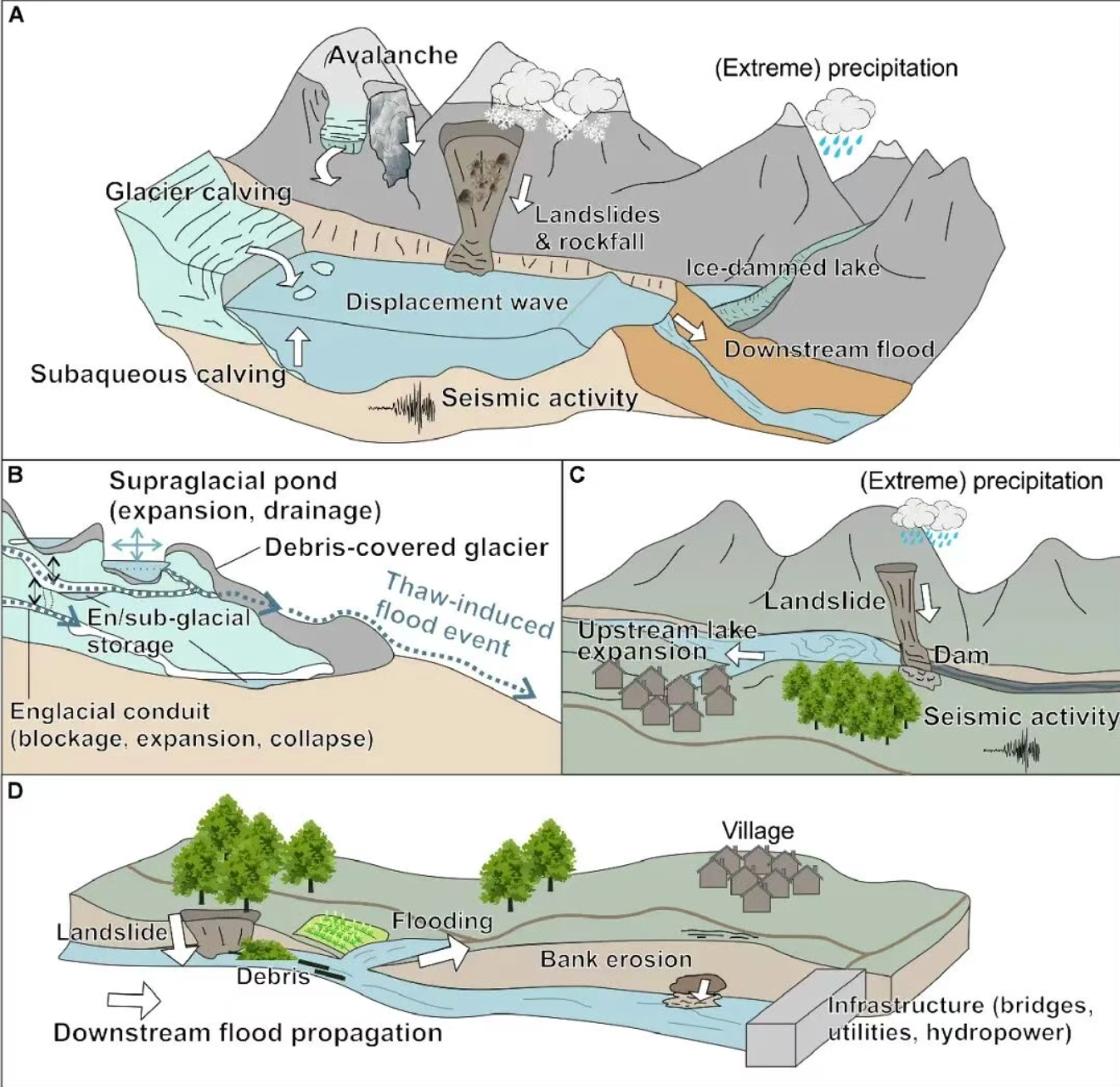
So the impact of climate change is no longer just increasing the risk of a single hazard occurring. It is also altering the physical links between different hazards.
This is what I call the “changing geography of climate risk”: a world in which where disasters occur, where they travel, and which people and infrastructure are exposed to risk are all changing with climate change.
The Himalayan region is a prime example, but by no means the only one.
From too much water to too little water
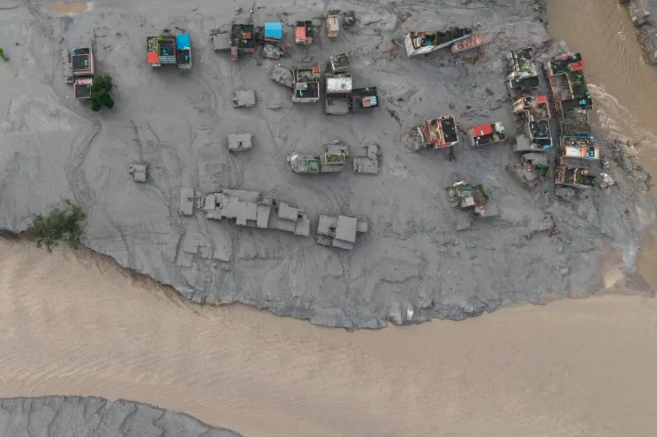
China provides a vivid illustration of the other side of this shifting geography of risk. While the Himalayan disaster began in the frozen terrain high on Nepal’s border with Xizang, other parts of China have recently faced unusually heavy rainfall. Heavy rains associated with tropical weather systems have triggered floods, landslides and mass evacuations, demonstrating how quickly rainfall can evolve from a meteorological event into a geological disaster and then into a humanitarian emergency.
What matters is not just the rainfall itself, but the cascading consequences. Water saturates soils and destabilizes slopes; landslides destroy homes and roads; rivers overflow; transportation networks are disrupted; and even communities far from the storm’s epicentre can be drawn into an expanding geography of risk.
However, all the way west from China to Europe, the problem is almost the opposite.
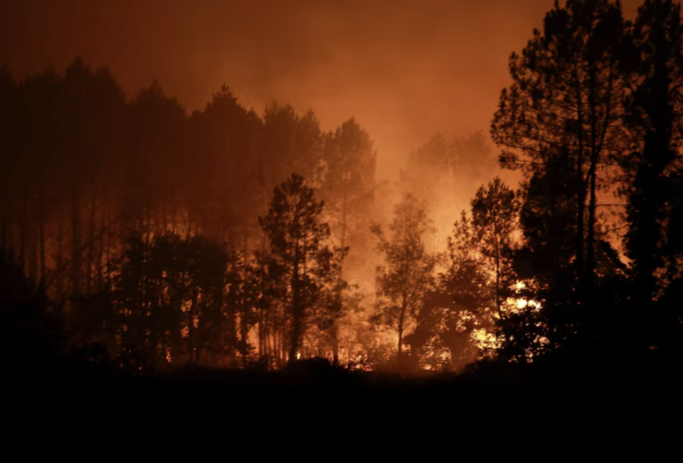
In the summer of 2026, large areas of Europe experienced unusually severe heat and drought. Major rivers such as the Loire, Po, Rhine, and Danube fell to unusually low levels, while dry vegetation and soil further exacerbated the severe wildfire risk. The impact went well beyond the natural environment itself: low river levels affected shipping and water supplies, and insufficient cooling water and declining hydroelectric power generation also put pressure on the energy system.
France provides a particularly stark example. The summer of 2026 was France’s hottest since national weather records began in 1900. Multiple heat waves coincided with severe precipitation shortfalls, unusually dry soil, and destructive wildfires.
Again, the key here is not just “heat” or “drought”, but the interaction between the two. Heat intensifies evaporation, droughts dehydrate soil and vegetation, and dry vegetation fuels wildfires; reduced river water flows affect transportation and electricity production. The same climate pressures are transmitted to agriculture, ecosystems, public health and the economy.
As a result, the geography of climate risk is shifting in seemingly contradictory directions: destructive water gluts in some places and dangerous water scarcity in others. The common factor behind the two is a climate system that is accumulating more energy and moisture, altering the environmental conditions under which societies are organized and run.
The changes are stretching further. Drought and record-high temperatures in parts of North America and Europe are putting forests under increasing pressure, not only exacerbating wildfire risk, but also causing deforestation and making them more vulnerable to pests and diseases. Meanwhile, on coastlines around the world, rising sea levels and erosion are gradually changing the boundary between land and sea, while communities, ports and infrastructure remain where they were originally built.
What ties these phenomena together is not geographical proximity, but a shift in the physical environment itself.
The future has arrived
The scientific evidence surrounding this shift has become increasingly difficult to see as isolated warning signs. The 11 years between 2015 and 2025 were the warmest in observational records. In 2025, the heat content of the oceans once again hit a record, while the concentration of greenhouse gases in the atmosphere continued to remain at unprecedented levels.
Glaciers in the world’s major mountain regions continue to retreat, and the Greenland and Antarctic ice sheets are losing mass. At the same time, changes in heat and precipitation patterns are affecting forests, rivers, agricultural systems and human settlements thousands of kilometers away from frozen regions.
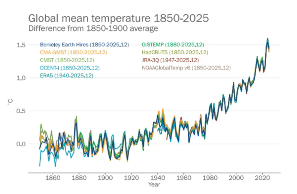
We are no longer facing a few scattered signals, but a changing earth system.
And this may be the greatest difficulty.
Civilization is highly spatially fixed. Political boundaries remain largely where they were originally drawn. Cities, roads, bridges, dams, ports and power stations remain where they were originally built. The maps, engineering standards and planning assumptions used to protect these facilities and settlements are also largely based on observations of past environmental conditions.
But the physical environment around them is becoming increasingly unstable. Some regions are seeing more water than expected, while others are running out for longer; permafrost is melting as glaciers retreat; persistent heat is changing forests and landscapes; and rising sea levels are gradually driving changes to coastlines that coastal settlements cannot simply move with.
The future has arrived一一它并不是以某一场单独的气候灾难降临,而是表现为人类文明赖以运行的整个物理环境正在发生转变。
When resilience must come before disaster
And this brings us to the issue of resilience.
Resilience has long been understood primarily as survival from disasters and post-disaster recovery and reconstruction. These capabilities remain critical, but they only come into play after problems have already occurred.
This is no longer enough.
If we can no longer take for granted that yesterday’s physical environment will remain the same tomorrow, then rebuilding yesterday’s infrastructure in yesterday’s place may simply replicate tomorrow’s fragility.
Resilience must therefore begin before disaster strikes. It means observing environmental changes, anticipating where risks are moving, adapting infrastructure and land-use practices, protecting vulnerable populations, and, if necessary, changing how and where we build.
The traditional path is often
Disaster-Response-Recovery-Reconstruction
The emerging climate reality calls for an alternative path:
Observe – anticipate – adapt – protect – transform
This isn’t just a difference in wording. It changes when society takes action, and exactly why.
The Himalayan region in particular illustrates this point. A village does not need to be close to a glacier to be exposed to glacier risk. It may be tens of kilometers downstream, but it is connected to the glacier by a hillside, river, road or hydroelectric system. The same principle applies elsewhere: a city that is not directly burned by a wildfire will suffer the consequences of a wildfire if it destroys its catchment area; an industrial center, even if it is not directly affected by a drought, will also be affected if the river level drops and disrupts the transportation or energy systems on which it depends.
Therefore, the tragedy of Langtang Lirong Peak leaves us with a far bigger question than “what exactly caused a mountain to collapse”.
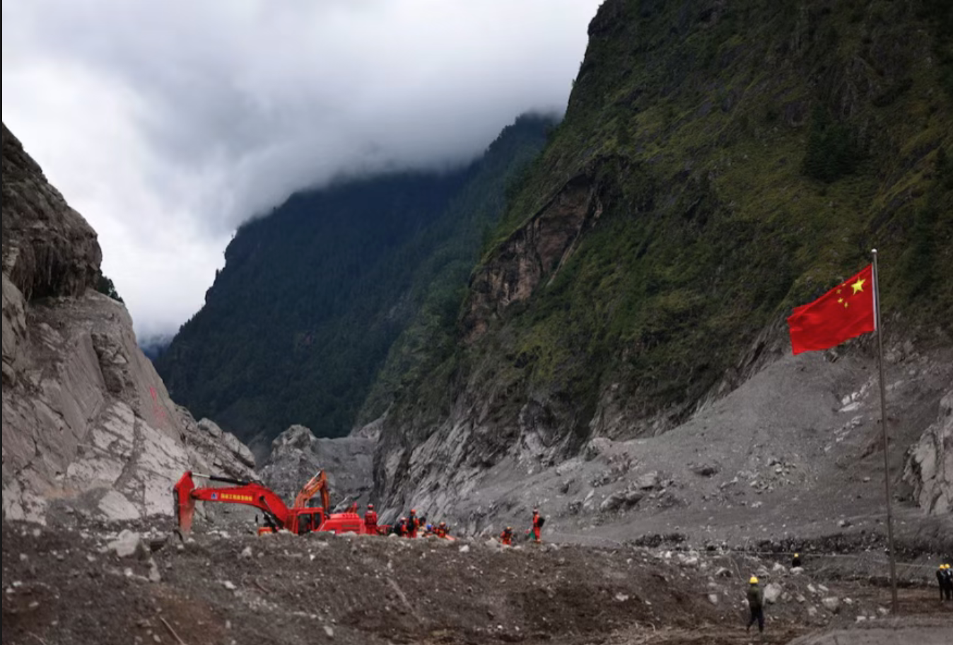
It asks: Is our perception of risk changing at the same rate as the physical world around us?
Climate change doesn’t move political boundaries, but it is pushing some of the physical boundaries on which human civilization rests: the boundaries between ice and water, between freezing and melting, between rivers and settlements, between forests and fire zones, and between habitable shores and approaching oceans.
If the geography of risk is changing, the geography of resilience must change with it.
When glaciers continue to retreat, rivers break through their historic boundaries, forests become more flammable, and even mountains begin to move, it is no longer considered resilient to wait until disaster strikes before adapting.